A585 Consultation
 There's a plan afoot to make some significant road
alterations between the River Wyre Hotel at Skippool and Windy Harbour traffic lights. There's a plan afoot to make some significant road
alterations between the River Wyre Hotel at Skippool and Windy Harbour traffic lights.
It's a topic we've looked at before, and if you read through our previous articles, a clear pattern emerges.
It's a pattern that saw an ambitious vision beaten into submission by bad judgement to become a miserable relic of a road scheme that is now on the cards.
We went to see the exhibition at Singleton to get the griff for our readers.
The highwaymen from 'Highways England' (the new persona for the former Highways Agency, and before that, the Department of Transport) were unfailingly polite and
willing to engage (to use the vernacular of the day) with us to discuss what they were up to and why.
As we wended our way around their display tables and spoke with them, we formed the conclusive view that we were not at all keen on ANY of the options that they were
proposing, but we lay the blame less with the highwaymen and more with their lords and masters who had devised their brief and set the parameters in which they had to work - as
we shall explain....
SYNOPSIS
We begin with a Prologue, a quick preface to the story, then a short Background highlighting our previous articles on this matter.
Next we look at an overview of the Present Idea before looking in some detail at Option1 which is the preferred option of the highwaymen.
Next we look at an alternative called Option 2, before outlining a Quick comparison of the options.
Then we look at What happens next, and What others have said: first Lancashire County Council, then
Wyre BC, then Business, Singleton PC, Fylde BC and some public comment,
before offering our own Analysis and alternative suggestion, before coming to a Conclusion
PROLOGUE
In December 2014, Grant Shapps, the then Chairman of the Conservative Party, came to what many locals know as 'Catlows Corner' (but is probably better described as being
where Mains Lane meets the Garstang Road). He was accompanied by other Government luminaries including Paul Maynard MP and Mark Menzies MP, and lesser local ones -
including Wyre's Chief Executive and Council Leader. He came to highlight plans for a (then) £41.3 million (now £50m) link road between Windy Harbour and Skippool, as
part of his announcement that had detailed 84 new national road building projects.
It gave the green light for what is now the roadbuilding equivalent of a £50m pothole patch to be applied to the A585.
BACKGROUND
We can be brief.
How we got here, and most of the arguments that are involved, are already set out in our previous articles.
First in 'Red and Yellow and......' in 2006 where we looked at the original five main options for a new road:
Red; Yellow; Blue, Purple and Pink - (together with their several sub-options).
Next, in 'Road Relief for Some' in 2007 we reported that the original 'Red Route' had joined the
Dodo. It's 'protected' status had been removed. It was now never going to happen. The Yellow Route was gaining ground (except in Singleton where it would cause significant
damage), and we concluded that article with what has turned out to be a fairly good prediction: "It will take some time before anything happens on the ground, probably
ten or twelve years"
Then, in 'Road Going Nowhere?' in 2008 we showed how the political leaders - especially in Fylde and Blackpool
- were distancing themselves from expert opinion and the public's preference for the Yellow Route, and heading toward supporting something called the Blue Route. But it was as
clear as a bell to us that this Blue Route would never be built.
Finally, in Transport Masterplan? (2015), we looked at what was, in effect, the County Council's
abandonment of the scheme to build a fast road from Fleetwood to the Kirkham Junction on the M55 altogether. Like the Red Route before it, this idea is now on 'life support'
pending wider acceptance of its demise.
That will undoubtedly follow the adoption of what is now proposed.
The LCC 'Masterplan' changed tack somewhat, and heralded the current, miserable, little proposals, (the so-called Poulton le Fylde section) and its various options,
which are now open for comments during a consultation
period that ends on Monday (17th October).
SO WHAT'S THE IDEA NOW?
Superficially, the idea is still supposed to improve the road from Fleetwood to the Motorway, but the reality of this plan is that, at best, it will do little more than move
the problem from one place to another.
Basically there are two options. One of these picks up on Mains Lane more or less from the petrol station near the River Wyre Hotel, then goes across country to a new
roundabout on Garstang Road East a few hundred yards past the Cemetery going from Poulton (probably a bit before the point where there was a fatal accident a while ago, and
memorial flowers are usually tied to one of the tree trunks).
It then has a very controversial section where, instead of following what was originally going to be the Yellow Route across the fields to the M55, it turns left and crosses
Singleton's Lodge Lane more or less at the entrance to Singleton Hall before going further east (toward Garstang) and slightly north to another new roundabout on the existing
road more or less at the patch of woodland in which Bank Hall sits. It then uses the new section of road that has been built to reach the Windy Harbour traffic light junction.
And that's it.
The second option picks up again near the River Wyre and crosses the fields to Garstang Road, but this time it lands a bit further from Poulton and is roughly where the
lay-by is now. At this point a new 'gyratory' system (that has to be seen to be believed) is applied to the new section and the existing roads to create what is in
effect a huge triangular 'roundabout' with it's three extremities being Catlows traffic lights, the lay-by, and a point on Mains Lane just before 'Beryldene' - the big house in
its own grounds where George Formby once lived. The rest of the road (after Catlows) is more or less as it is now, and there is no 'southerly by-pass' across Lodge Lane and
there looks to be no change at all to the south of Garstang Road.
There is however, a change at the junction of Mains Lane where the road leading to Shard Bridge begins. This (probably) sees (another) huge roundabout.
One decision that has already been taken (it seems) is that the former 'Northern Sub Option' to link Mains Lane around the back of the houses on Mains Lane (follow
this link to see a map showing it), has now been disregarded. We understand this is chiefly because it has a greater cost, and because it may risk disturbing the wild geese
etc, whose European-inspired Special Protection Area (or SSSI - or maybe both) is a bit closer to the river Wyre itself. (Though whether legislation like that will
ultimately survive 'Brexit' is another matter).
So that's an overview.
Speaking of which, you can follow this link see an interesting 'flythrough' video of Option
1 which the highwaymen have put on You Tube for as long as it lasts there.
We're now going to look at the schemes in more detail.
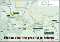
OPTION 1
We should say at the outset that the photographs (below) of the maps were taken at the public exhibition. They are heavily marked as an 'Indicative Layout' so
they should not be regarded as the final plans, but they do help our readers to get a better overview of what is planned.
Starting at the Skippool end, there are changes at the existing roundabout and it looks to us as though this will change to become a bigger junction, probably controlled by
traffic lights. There looks to be a new bridge to carry the new road over Skippool but it won't look that much different than now (except that there looks to be some sort of
underpass at this point).
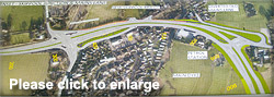
Moving toward Garstang we see a hugely complicated junction where (what will become) the existing Mains Lane, and a diverted Old Mains Lane allows traffic to and from
both these locations to join the new road. When we saw this layout we were put in mind of the junction at Dobbies Garden Centre at Clifton where a minor road meets a fast
moving one. It works, but somehow it doesn't feel quite right, this one looks to be even more complicated and seems to have one or two roundabouts incorporated into what looks
to us to need a traffic light controlled junction.
From what we can see of the layout, this arrangement seems to be necessary because the (apparent) abandonment of the roundabout by the River Wyre and its change to what we
expect will be a traffic light junction will mean that anyone heading toward Fleetwood on the 'new road' and wanting to get onto Mains Lane (the bit between the River Wyre
Hotel to the Over Wyre turn) will have to be able to cross the traffic flow coming *from* Fleetwood and turn back on themselves to go up Mains Lane.
There's a famous cartoon (although mostly intended for, and related, to computer folk) which clearly illustrates how trying to deliver a bad specification ends up as
a real mess. Readers can follow this link to see The Tyre Swing Cartoon. The design of this junction puts us in mind of the
cartoon. It's simply awful.
Moving along the road, from the graphic below we can see the route and location of the new section of road across the farmland, cutting round the back of the longer
commercial properties on Mains Lane and where it joins onto Garstang Road East with another big roundabout.
Although we regret the loss of farmland to another road, (and assuming the farmer is properly compensated for his loss), this is probably the least controversial part
of the proposal. It appears to follow the line of the southern option of the original 'Yellow Route.'
But from here, the trouble really begins.
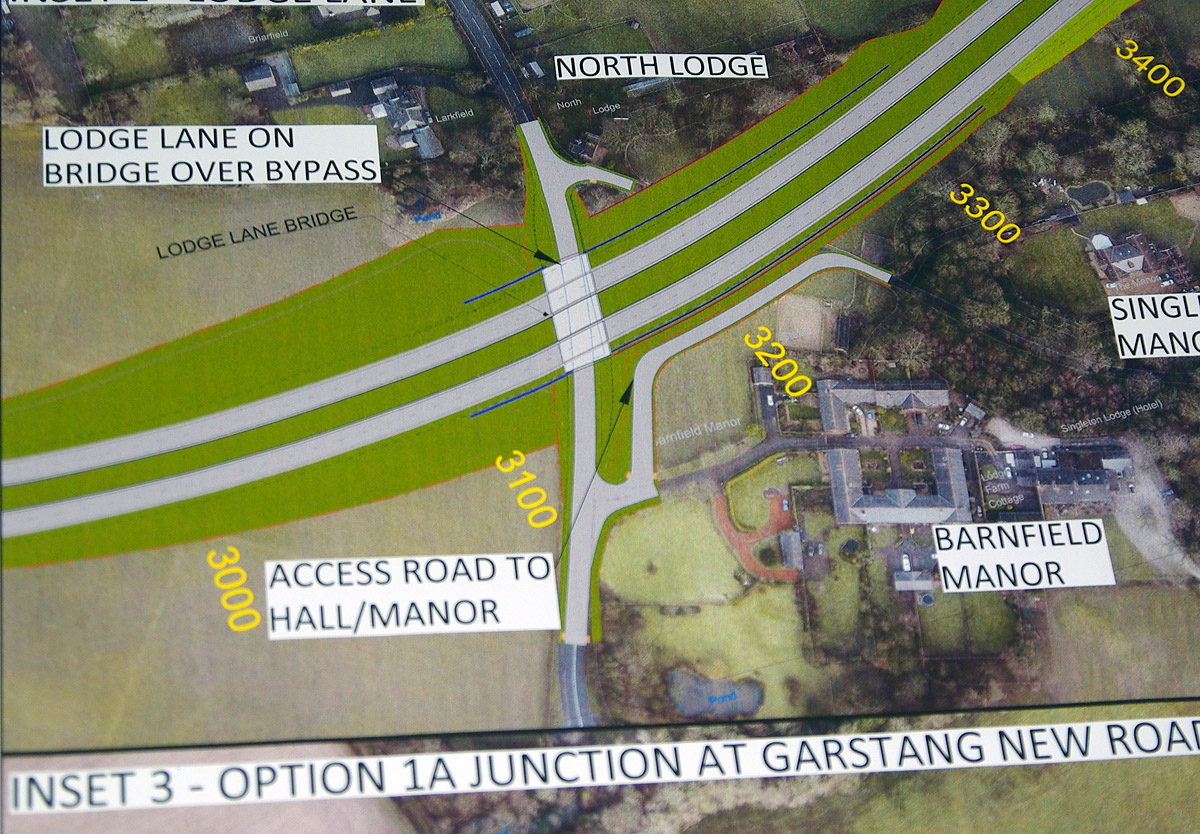
Instead of simply providing and access onto Garstang Road East another new section of road goes east to by-pass the five ways Catlows traffic light junction.
But in order to do so, there will be very significant earthworks to form a cutting (like a very long railway cutting) that goes UNDER Lodge Lane which itself is supported by
a new bridge.
The next picture shows this in more detail.
It also shows that on its south side, the supporting work for the cutting begins between the present entrance to Barnfield Manor and the sharp bend at the foot of the slope.
Because of the damage the cutting does to the existing topography, the associated works have to provide completely new entrances to Barnfield Manor, Singleton Hall and a
rear entrance to Singleton Lodge Hotel.
That damage becomes evident as you travel up Lodge Lane and cross what will be a bridge (we think it will be a bit higher than the present road level but are not sure about
this) over the new Southerly By-Pass, to land virtually just outside the gatehouse for Singleton Hall. The excavations for the By-Pass truncate what was the driveway to the
Hall, and necessitate the new access we mentioned earlier.
Moving further along, the proposals are unremarkable except that (as can be seen from the image below) somewhere around Bankfield House it rejoins the existing Garstang Road
and the recently altered junction at Windy Harbour.
There are two options for the bit of Garstang Road between Catlows traffic lights and the point at which the new Southern By-Pass joins the existing Garstang Road. Sub
Option 1a puts a roundabout there and leaves the section up to Catlows open. The highwaymen think this is less likely to remove traffic from the present route.
Sub Option 1b closes this section of road altogether. They think this should improve journey times and remove more traffic from the existing route but it might need a
footbridge at one point.
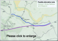
OPTION 2
Sad to say we've no photos of this, only the plan below. (That's probably a measure of how important the highwaymen think this option is - they've not spent money on getting
'aerial view' type pictures, or we at least didn't see them at the display).
As we said earlier, this option picks up again near the River Wyre and crosses the fields to Garstang Road, but this time it lands a bit further from Poulton and is roughly
where the lay-by is now.
That's where the new one way, two lane 'gyratory system' and a new 'link road' from Garstang Road East to Mains Lane creates what is in effect a huge triangular 'roundabout'
with it's three extremities being Catlows traffic lights, the lay-by, and a point on Mains Lane just before 'Beryldene' - the big house in its own grounds where George Formby
once lived. The rest of the road (after Catlows) is more or less as it is now, and there is no 'southerly by-pass' across Lodge Lane, and in reality there looks to be no change
at all to the south of Garstang Road.
There is however, a change at the junction of Mains Lane where the road leading to Shard Bridge begins. This sees (another) huge roundabout, and it will be positioned north
east of the existing junction.
But this scheme does see the section of Garstang Road from Catlows to Windy Harbour turned into a dual carriageway.
The higwaymen are not so keen on Option 2 because it's not as good as the other for shortening journey times and (probably crucially) they say it doesn't allow as much extra
growth and development to be added in future (Option 1 is expected to allow yet more houses and employment land to be created in Thornton and Fleetwood).
And finally they're not so keen on this one because (they say) it doesn't "....reduce the impact of traffic on local communities as much as the bypass"
Try telling that story to the folk around Lodge Lane! (Though to be fair, we can see there are numerically more folk on Mains Lane)
A QUICK COMPARISON OF THE TWO MAIN OPTIONS
Option 1 Benefits:
- It gives the better improvement in journey times,
- Preliminary work suggests it could offer better air quality for walkers, cyclists and pedestrians (because the A585 stretch would be de-trunked)
- It would also provide less traffic noise between Little Singleton and Skippool
- It gives the better improvements for cyclists and pedestrians
- Relatively slight disruption for residents and businesses during construction
- Less disruption to traffic whilst it is built
Option 1 Detractions:
- Needs a lot of land to be reformed
- Much more costly
- There may be more noise at the rear of properties on the south side of Mains Lane and around Lodge Lane, south of Little Singleton.
- Take longer to build
Option 2 is more or less the opposite of these except the noise from the 'gyratory' needs to be factored in, and that from Lodge Lane removed.
|
WHAT HAPPENS NEXT?
We're currently toward the end of the first phase that identified the options and are now in the process of refining which to use.
As ever, we're less than excited by this consultative arrangement.
The options have been identified before local people have been consulted. As a result, there are only two options that are really available for consideration. We believe the first consultation should have been about the
parameters that the designers were given before they started work to identify what options might be available.
Rant over (for the moment).
The next stage is due to start in Spring 2017, and is what's called the 'Development Phase'. That involves a preliminary design and an application for planning permission
etc. Then there will be an examination of the scheme by the Planning Inspectorate and a decision by the Secretary of State as to whether to proceed with it. Once that gets the
go ahead (or not) the highwaymen begin to prepare for the construction. We imagine this will involve land assembly, preparing specifications and contracts and so on.
The final stage is the 'Construction Phase' when the diggers move in and the road gets built. This isn't expected to be before 2020. Our own guess is that (if it is built at
all) it will be a bit later than that. So we'd guess a date of something like 2023/24 before we see traffic on it.
WHAT OTHERS HAVE SAID ABOUT THE PLANS
Lancashire County Council
The Gazette Reported LCC's Leader (Cllr Jennifer Mein) saying she wasn't sure if it would go ahead or not, but if it didn't the money would not stay earmarked as being for
Lancashire, adding "I believe this is a scheme which would bring benefits to that area of Lancashire, and these proposals do not preclude the Blue Route from being built in the
future"... She praised the consultation (as with one exception so do we), saying it was well handled by Highways England.
From that, we're reasonably comfortable in believing that LCC will support the plan. (Though why on earth they're *still* talking about the Blue Route heaven only knows)
Wyre Council
We've not seen anything published, but we're told that Wyre are playing hardball to get this scheme approved. They would do that of course. They want to be able to develop loads
more housing and employment land in the Thornton and Fleetwood areas and they need to have something to justify approving planning applications.
The fact that it will make almost no difference (because it solves nothing between Fleetwood and Armounderness Way, and it solves nothing between Windy Harbour lights and
the motorway) seems lost to them. But what they seem to think it will do - especially in conjunction with the Enterprise Zone that's planned for the former Hillhouse ICI site -
is provide an arguing chip to justify lots more houses being built.
This pursuit of illusory growth is something we've spoken of before. It's simply not sustainable in the longer term and it is damaging the farmland we need to be able to
feed ourselves from, as more and more farmland gets built on.
We heard tell of a private meeting that had taken place a week or two back where the highwaymen had handpicked ten or so local politicians and businessfolk. We
heard it was 4 or 5 Wyre senior councillors and officers, and a chap from a Thornton plastics company and a chap who has a big machinery maintenance business and probably one
planner and one Cllr from Fylde. We didn't get much detail of what went on, but the fact that it was a private meeting always sows suspicion, and it was almost certainly about
letting Wyre's hierarchy spread their influence.
Now we hear that unless Fylde Council support the road proposals, Wyre are threatening to object to Fylde's Local Plan. Their argument seems to be that if Fylde don't agree
to support the road, they say they will lose the prospect of something like 3,000 extra houses, and if they can't have the road to justify building them, they will argue that
Fylde should build them in its land under something called the 'Duty to Co-operate'
We imagine that will be land in Fylde, but close to Poulton or Skippool.
We liken this approach the 'Get to the back of the queue' argument deployed by the US President in support of David Cameron's complete misjudgement of the will of the
British People.
We would make it clear to Wyre that Fylde residents have even harder balls, and our response would be the same as the UK said to the US President in the referendum.
It would be short, and ending in 'off'
But we suspect Fylde Council will buckle and support this road.
Business
Predictably, the business supporting organisations are expressing varying degrees of support for the proposals. That's not unexpected.
Singleton Parish Council
In the Open Forum section before a Parish Council Meeting, various aspects were raised.
It was noted that Highways England seem to be only supplying limited information and appear only to wish to deal directly with landowners and home owners at the moment. The
Parish Council had been kept somewhat in the dark. The PC did hope to invite Mark Menzies MP to a future parish council or a specially convened meeting.
The situation is complicated in Singleton because a number of councillors have a personal interest in whichever option might be chosen. Some live near the routes, some may own
gardens or land that will be lost to it.
Cllr Chew had told the meeting that on this occasion, Highways England was instructed by the Ministry of Transport to come up with 3 options. The first of these was
problematic because of land conditions near to the river and it would have meant displacing a lot of people. The second route is gyratory and is not going to fulfil all the
requirements of an improved traffic system away from the traffic lights. The third route cuts across fields from Garstang Road to the south side of the village and this is the
route they are favouring at the moment.
The meeting was told that a new Enterprise Zone is being declared at the former ICI works and Wyre Borough Council wants to build a lot more houses. They cannot do this
before the road network is improved and therefore the 3 MP’s in Wyre are putting a lot of pressure on this. It was said by someone at the meeting that our own MP, who procured
the funding, needs to stand up for his residents and try and find a solution that will be acceptable to all.
So the tone of the forum was unhappy, and we were surprised that the Parish Council was being excluded as the official body that represents local residents.
Fylde
We're not clear whether or how Fylde might comment on this proposal. In the (proper) old days, there would have been a debate at full Council with elected members from that
area being given ample opportunity to put the point of view for their community. In today's imitation of reality, it's quite possible that our elected councillors won't even get
to discuss it because they have delegated so much of what they should be doing on our behalf to their officers, and we would not be surprised if an individual officer decides
what view the Borough Council has on this matter.
If that is what happens, we regard it as outrageous.
Fylde has made comments on how to deal with traffic management at Catlows before of course. In 2002 - on a completely different scheme - they responded to a consultation from
LCC.
At that time LCC reported: "The Borough Council opposes any improvements at the junction, including any modifications to the existing signal layout. The Council has
expressed concern over the impact of a roundabout on access to and egress from businesses and properties, and on the approach speed of vehicles to the junction.
Furthermore, it is concerned about road safety in general on the A585 in Fylde, in particular, the section through the villages of Greenhalgh and Esprick, and considers an
improvement at Little Singleton in isolation to be unacceptable.
The Council is to seek a meeting with the Highways Agency to discuss further its concerns about the A585, including the proposed junction improvement at Little Singleton. A
verbal report will be given if this meeting has taken place. Strategic issues relating to the Fylde Coast Easterly Bypass were discussed at a joint meeting held on 26 February
2002, between the County Council, Fylde, Wyre, and Blackpool Borough Councils. All parties agreed the need to pursue a Route Management Strategy for the A585 and to continue to
lobby the Highways Agency and Government Office North West over the retention of Trunk Road status. Fylde Borough Council restated their concern regarding the provision of a
roundabout at the Singleton Crossroads junction."
Whether those views remain holding sway now, is unclear - especially as they appear to be under threat of having their Local Plan held up with an official objection from
Wyre, and risk it running outside the March time limit Government has set.
Public comment
Most of the public comments we've heard are negative. That's partly to be expected, it's less common to hear people warmly embracing change.
But in this case we think the negative comments have some justification. That's because public expectations were lifted - with first, the Red, then the Yellow Routes. But
what's being proposed now is nothing like either of them.
The main focus of complaint we have heard from existing residents is that it is too little too late. It will do almost NOTHING to improve the traffic trying to get from
Fleetwood or Thornton Cleveleys to the M55.
That's because the stretch from Windy Harbour to the M55 is having nothing done to it. Zero. Zilch.
So, they say, all this is going to do is to shift the problem, and we know that moving a problem elsewhere *never* solves it.
We've also heard some folk on the Fleetwood side of the Armounderness Way roundabout complaining bitterly that (what we consider to be) the 'new' road past Norcross and up
to Fleetwood is ALREADY choked with congestion - and that's not related to Mains Lane onward.
So we're not at all sure that those in North Fylde will be as welcoming of the plan as their political counterparties seem to be.
Whilst we were at the exhibition, we heard People speaking with the - very pleasant, courteous and long suffering - staff manning the various stalls. To us, most seemed unhappy
and we said to one of the chaps that it must be difficult for them to be constantly bombarded with folk who didn't agree with what was planned.
He said that wasn't the case
because there had been quite a few folk on Mains Lane who were very supportive of the idea that the traffic they currently endure was likely to be diverted to Garstang Road
East if the preferred option was chosen.
That's a problem. The plan is dividing feelings amongst the local community and in some cases causing friction within families and between neighbours. This sort of
thing makes it really difficult for hardworking councillors like Cllr Maxine Chew who has been a tireless campaigner for the best solution for her constituents, but when a
plan
improves things for a few and worsens it for others (she also covers the area further along the route in Greenhalgh), it presents a situation with no easy solution.
If she argues
against this 'token gesture' of a road scheme she would be going against he wishes of some of her constituents, and vice-versa
In our own conversations with the highwaymen, we came to the view that, within the brief they had been given, they had probably done as good a job as they might have been expected.
But we came away with the clear impression that the parameters they had been told to stay within when designing the road were such that it was not possible to produce a proper
solution. What was being produced was a multi-coloured sticking patch plaster over a gaping wound. That's why we likened it to a 'pothole patching' exercise at the start
of this article.
ANALYSIS
What we have here is really a story of how the *purpose* of the various road plans have changed over time.
The aim of the original Red Route was to become the Blackpool By-pass. It was to provide a fast north-south route running well to the east of what were then the arterial
north-south roads (The Promenade and Whitegate Drive/Devonshire Road).
The Red Route was effectively abandoned when the Yellow, Blue, Pink etc options were mooted. The purpose of these roads was not to by-pass Blackpool, but to open up areas of
Fleetwood and Thornton Cleveleys for housing development and the creation or redevelopment of employment land by providing a fast clear route to the Motorway.
In our view, having embarked on the housing and some of the employment land, that should still be the aim. And to us, the logically obvious route is the Yellow route - the
'diagonal' road from the River Wyre hotel across farmland all the way to the M55 junction at Kirkham.
There is something of a case to be made for the Blue Route now that it has abandoned the idea of a separate motorway junction and now aims to land at the Whyndyke Farm
motorway roundabout, but in our view it come so far west from Fleetwood that we're not confident it can provide the fastest way to the Motorway (and it's definitely a longer
way round on 'two sides of a triangle' )
But it now looks as though even the yellow route is being abandoned, and the preferred plan is to spend a lot less dosh on a solution that goes nowhere near providing a fast
route to the motorway.
If we accept that the aim is only going to be to ease the flow as far as Windy Harbour (and that's nowhere near being a *solution*) it quickly becomes clear that the
fundamental problem is the five ways junction at Catlows. It's also clear that the latest plan is trying to accommodate too many needs.
In our view it should focus on the primary issues - getting the traffic as quickly and easily as possible from Fleetwood and Thornton Cleveleys and Blackpool to and from the
motorway, and if that means inconvenience for others, that's what it will have to mean.
So the idea of meeting the needs of cyclists and pedestrians (and wildlife for that matter) on what is, in reality, a primary distributor road, ought to be very low down the
table of importance.
Whilst we still think the Yellow Route ought to be implemented, if the present 'sticking plaster' purpose of the road holds sway, then our own approach would be neither of
the ones currently on the table.
We would change the point at which you decided whether you were going to Thornton/Fleetwood/Over Wyre, or whether you are going to Blackpool or Poulton.
Currently you make this decision at Catlows.
We would move it so the decision is taken at the Windy Harbour junction.
The existing road would become the road to and from Blackpool, (but using an extra bit of the farmers field to the left of the present Catlows junction at the top of the
hill going toward Blackpool - so as to move it a bit further south until it reaches Lodge Lane), and we would create a second road from Windy Harbour - one that starts
maybe 50
yards down toward the caravan site and runs inside the present hedge up to and to join with Mains Lane.
We don't claim to be highway engineers and there needs to be thought about the detail of the Windy Harbour junction and the Shard Lane one, but the important principle is to
create as seamless a traffic flow as can be achieved We believe there is room to provide two separate routes, one to and from Fleetwood and one to and from Blackpool if the
purple line alters slightly south of the existing road to make room for the blue one to Fleetwood.
To keep the traffic flowing, this would mean closing off the access for Lodge lane at the top of the hill and closing off the top of Pool Foot Lane as well. Those wanting
access to Pool Foot Lane could have the present blocking off of this road removed and reversed, so it would become blocked off at the top of the hill and reopened at the other
end where traffic would exit onto the Windy Harbour road and up to the (present) traffic light junction which might be faster if it became a roundabout.
Those on Lodge Lane would have to go through Singleton village and along 'mile straight' to get onto the A595/ Or they could reach Blackpool and Poulton and Staining via a right turn in
Singleton village and through to Hardhorn.
This will inconvenience residents in both these roads but, if the aim is to get traffic to and from the motorway it seems to us to be the obvious choice.
If you use the 'flyover video', you can actually see (what would be) the route of the suggestion we're making because it is approximately represented by an earthwork track
on the right of the screen just after the video turns toward Blackpool at the Windy Harbour junction.
CONCLUSIONS
This is controversial decision, with people and organisations lining up on both sides. To us, it looks as though more will line up on the side that will see the preferred
option implemented.
That's because some simply want the money to be spent on any sort of road improvement; and some think it will create prosperity and employment, whilst a smaller number think
it will ruin their lives.
We suspect most people on the 'Clapham Omnibus' will think it is too little and too late, and it won't solve anything.
We find ourselves in that camp, and (assuming our idea of the extended Windy Harbour junction is not taken up), we would argue for only the section from the River Wyre to
Garstang Road East (ie the line of the former Yellow and Blue Routes) to be built at this time, thus avoiding the awful cutting across Lodge Lane, and leaving open the option
for more sections of the Yellow route to be built in the future.
Those with excitement or concerns at the prospect now proposed
have only until Monday 17 October to make their views known at the Highways England online consultation
website
Dated: 14 October 2016 
|